
Integrating Multi-Networks of GNSS and Precise Leveling for the Estimation of Orthometric Heights in the Owerri Region and Its Surroundings, Imo State, Nigeria.
Authors
Abstract
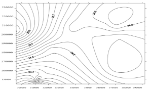
Orthometric heights obtained from GNSS require geoid models to convert precise ellipsoidal heights (h) into orthometric heights (H), crucial for various applications such as cadastral, surveying, mapping, engineering, and environmental work. While GNSS typically uses global geoid models like EGM96/EGM2008 for height conversion, these models may prove inadequate for local applications, particularly in the absence of a national geoid model. This research aims to model orthometric heights in the Owerri region of Imo State, Nigeria, using multi-networks of GNSS and precise leveling data. The research utilizes a dual-base reference station approach and static 2-hour DGPS data capture. Polynomial models, including a multi-quadratic model and a bi-cubic model, are used to represent the Owerri region's surface. The least squares method is employed to determine model coefficient parameters, which are used to develop a geometric geoid model program in Microsoft Excel 2010. The standard deviations of the geoid model-determined orthometric heights are 11 cm for the multi-quadratic model and 14 cm for the bi-cubic model. Statistical tests, including t-tests, confirm the accuracy and reliability of the multi-quadratic model for modeling orthometric heights. The model's high coefficient of correlation (R) and coefficient of determination (R²) values indicate its strong predictive ability. Diagnostic tests further support the adequacy of the multi-quadratic model for geoid modeling. The developed model provides a reliable alternative for obtaining orthometric heights with centimeter-level accuracy, suitable for topographic maps and large-scale engineering plans. Kriging interpolation is used to generate contour maps, geoidal maps, and digital elevation models. This research recommends adopting the multi-quadratic model for everyday geospatial data needs in cadastral, mapping, engineering, and environmental applications.
Keywords: Orthometric heights; Geoid modeling; GNSS; Ellipsoidal height; Geoidal maps
1. IntroductionThe Nigerian geodetic network serves as a crucial infrastructure for precisely determining geographic coordinates, encompassing various parameters related to the Earth's size, shape, orientation, and position concerning the actual Earth's surface [1]. The roots of this network extend back to Nigeria's colonial era when it was initially established to support activities such as resource exploitation and efficient transportation within the country [2]. This network's development began with the creation of a leveling network in 1891, and it was subsequently expanded to include a triangulation network in 1912. These triangulations were computed using the Clarke 1880 reference ellipsoid [2], providing provisional coordinates essential for mapping purposes [3]. Heights were determined through vertical angle observations and, wherever feasible, levelling data was employed. The network was adjusted geometrically, with the coordinates at L40 serving as the reference point, and the mean datum was computed based on values obtained through triangulation, located at the northern terminus of the Minna base.
However, the Minna datum, established in 1928, has inherent limitations due to its arbitrary selection and the absence of triangulation data to the south and west of Minna [2]. Furthermore, the network's shortcomings are compounded by distortions inherent in the observational data [3], rendering it unsuitable for meeting the demands of modern positioning and geodetic projects. In addition, the geodetic reference system used in Nigeria is founded on the Clarke 1880 reference ellipsoid, with the origin not coinciding with the Earth's center of mass, but rather situated at one of the stations within the triangulation network [3]. These combined factors contribute to significant distortions within the Nigerian geodetic network, underscoring
interpolation is used to generate contour maps, geoidal maps, and digital elevation models. This research recommends adopting the multi-quadratic model for everyday geospatial data needs in cadastral, mapping, engineering, and environmental applications.
Article Details
Published
Issue
Section
License

This work is licensed under a Creative Commons Attribution-NonCommercial-ShareAlike 4.0 International License.
