
Downloads
A Comprehensive Study Of Maximum Building Area Estimation
Authors
Abstract
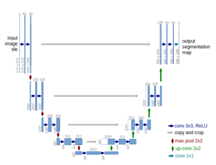
In recent years, with the increase in urbanization, it has become important to keep track of infrastructure in a geographical area. Urban planners rely on accurate building area calculations to assess the spatial characteristics and dynamics of built environments, informing critical decision-making processes. Satellite technologies have been developing rapidly and applied to many remote sensing applications due to which high-resolution images of a geographical area are obtained with much ease. To estimate the area of buildings we use deep neural networks to analyze images from high-resolution satellite data by extracting useful semantic features and segmenting all buildings. We then evaluate and compare four of these models to find how well each of these models segmented out the buildings from the image. After we train and evaluate, we compare the models based on the mIoU score with the Unet model (with ResNet18 encoder) obtaining the highest mIoU score (0.83).
Keywords: Satellite imagery, area estimation, Neural Networks, segmentation.
Article Details
Published
Issue
Section
License

This work is licensed under a Creative Commons Attribution-NonCommercial-ShareAlike 4.0 International License.
